Know Your Land Before You Make Your Next Move
Whether you’re farming it, buying it, selling it, or advising on it, Canadian agricultural land deserves more than a guess. SoilReport.ca is a new online tool that gives farmers, agronomists, and real estate professionals instant access to professional-quality soil and land capability reports for any agricultural parcel in Canada — drawn in seconds, delivered online, at a fraction of the cost of a traditional assessment.
What Is SoilReport.ca?
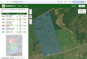
SoilReport.ca is a web-based platform that generates detailed soil and land reports from government-grade data sources — the same provincial soil surveys, Canada Land Inventory (CLI) classifications, and terrain data that agronomists and land appraisers rely on — delivered through a simple, map-based interface that anyone can use.
You draw your field boundary on the map. The platform does the rest.
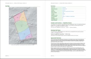
Within minutes you receive a report covering:
- Soil composition — what soil types are present, broken down by percentage of your parcel
- Canada Land Inventory (CLI) class — the national standard for agricultural land capability, from Class 1 (no significant limitations) through Class 7 (no agricultural capability)
- CLI subclass — the specific limitation factor: W for excess water, S for stoniness, C for climate, T for topography, and others
- Drainage class — well drained, imperfectly drained, poorly drained, and very poorly drained, mapped across your parcel
- Soil texture and slope — the physical characteristics that drive equipment decisions and yield potential
- Terrain analysis — slope distribution, elevation range, and surface depression indicators derived from LiDAR and national elevation data
- Wetland adjacency — proximity to mapped wetlands from the Canadian Wetland Inventory
Reports are generated as professional PDFs, ready to share, file, or include in a listing package.
Who Is It For?
Farmers and Farm Operators
You know your land better than anyone — but do you have the documentation to back up what you know? SoilReport.ca gives you a clear, organized picture of your soil types and land capability in a format lenders, landlords, and government programs actually recognize.
If you’re wondering whether your wet spots are worth tiling, the platform’s Terrain & Drainage Risk report tells you the slope, the depression areas, and whether your CLI subclass W acreage makes you a candidate for provincial drainage funding. If you’re applying for a tile drain loan or a federal AgriInvest program, having your land’s drainage class and CLI class documented in a professional report strengthens your application.
For farmers, the report speaks your language: CLI class, drainage class, your field’s soil codes, and a plain-English summary of what it all means for how you farm it.
Starting at $9 per report. No subscription required to get started.
Real Estate Agents and Agricultural Land Brokers
Agricultural land listings without soil data are incomplete listings. Buyers, their lenders, and their agronomists all want to know the CLI class before they make an offer. SoilReport.ca lets you generate a Property Assessment for any listing in minutes — a professional soil map and CLI summary you can include in your listing package, attach to an offer, or share with a buyer’s agent.
The reports are clean, branded, and built for disclosure. They cite government data sources, carry vintage dates, and are formatted for professional use.
A $29/month membership gives you unlimited Property Assessments — practical for agents who process multiple agricultural listings per month. One report pays for itself many times over when it helps a transaction close with confidence on both sides.
Agronomists and Crop Consultants
Your clients are making investment decisions based on what you tell them about their land. SoilReport.ca’s Desktop Soil Assessment gives you the full picture: complete soil series descriptions, horizon data, texture, organic matter, pH ranges, and CLI subclass detail — the data behind the map, not just the map itself.
The platform pulls from the same CanSIS provincial databases, AGRASID, and Ontario detailed soil survey data that you use in your practice, and delivers it in a structured report you can brand with your firm name, add your own narrative to, and hand to a client.
For complex parcels or multi-field operations, the platform handles the data retrieval so you can focus on the interpretation.
A $79/month Desktop membership covers all reports for your practice.
Why SoilReport.ca?
The data is already there — we just made it accessible
Canada has some of the best agricultural soil survey data in the world. Provincial governments, Agriculture and Agri-Food Canada, and Natural Resources Canada have invested decades in building the datasets that SoilReport.ca draws from. Until now, accessing that data meant knowing where to look, how to interpret GIS files, and having the technical tools to do so. SoilReport.ca removes every one of those barriers.
It takes minutes, not weeks
A traditional agronomic assessment involves scheduling, site visits, lab work, and report writing. SoilReport.ca doesn’t replace the agronomist — but for the majority of situations where you need documented soil and capability data quickly, it delivers in minutes what used to take weeks.
Government-grade sources, clearly cited
Every report includes the data source, the vintage date, and the data quality rating for each section. You know exactly where the information came from and how current it is. No guesswork, no black-box algorithms.
Affordable for individual farmers
At $9 per report, a single property assessment costs less than an hour of professional consulting time. Farmers who have spent years farming land without a single piece of paper documenting its soil capability can now get that documentation for the cost of a farm supply store run.
What’s Coming
SoilReport.ca is actively expanding its report library. Coming soon:
- Grant & Loan Finder — identify federal and provincial funding programs you qualify for based on your land’s drainage class, CLI subclass, and province. Ontario’s Tile Drain Loan Program, AAFC AgriInvest, and Sustainable CAP provincial programs, matched to your specific parcel.
- Best Use Analysis — for agronomists, estate lawyers, and lenders who need a formal assessment of what a parcel is best suited for under current soil and terrain conditions.
- Estate Full Report — a comprehensive land assessment for estate settlement, farm succession planning, and agricultural mortgage applications.
- Full French language support — reports and platform interface in French, for Quebec producers and francophone agricultural professionals across Canada.
Getting Started
Visit www.soilreport.ca and draw your first field. No account required for your first scan — see what data exists for your land before you decide whether to purchase a report.
For farmers managing their own fields, the $9 pay-per-use option is the simplest starting point. For real estate agents and agronomists who process land regularly, the monthly membership tiers offer better value and include additional report types.
Questions? Contact us through the site. SoilReport.ca is a Canadian product, built for Canadian agricultural land, by people who understand both the data and the land it describes.
Get an objective report of the soil quality, quick and easy.
SoilReport.ca draws from provincial soil survey data, the Canada Land Inventory, CanSIS national soil databases, NRCan elevation data, and the Canadian Wetland Inventory. Coverage spans all ten provinces. Data vintage varies by province and is clearly noted in each report.